Fil:Climate maps of Iran (Köppen-Geiger).png

Storleik på førehandsvising: 672 × 600 pikslar. Andre oppløysingar: 269 × 240 pikslar | 538 × 480 pikslar | 861 × 768 pikslar | 1 147 × 1 024 pikslar | 2 000 × 1 785 pikslar.
Opphavleg fil (2 000 × 1 785 pikslar, filstorleik: 312 KB, MIME-type: image/png)
.png)
Følgjande er henta frå filomtalen åt denne fila på Wikimedia Commons:
Skildring
| Skildring |
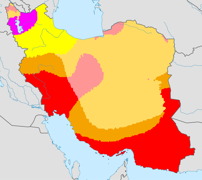
English: Climate map of Iran, using the Köppen-Geiger climate classification |
| Dato | (UTC) |
| Kjelde |
This file was derived from: |
| Opphavsperson |
|
Lisensiering:
Denne fila er lisensiert under lisensen Creative Commons Namngjeving-DelPåSameVilkåra 3.0 Unported
- Du står fritt til å:
- til å dela – til å kopiera, distibuera og overføra arbeidet
- til å blanda – til å endra verket
- På desse vilkåra:
- namngjeving – Du lyt godskriva verket på den måten som opphavpersonen eller lisensgjevaren har oppgjeve (men ikkje på ein slik måte at det kan verka som om dei går god for deg eller måten du nyttar verket på).
- del på same vilkåra – Om du remiksar, omarbeider, eller på annan måte byggjer på dette verket, kan du berre distribuera resultatet under den same eller ein samsvarande lisens som denne.
Opphavleg opplastingslogg
This image is a derivative work of the following images:
- File:World Köppen Map.png licensed with Cc-by-sa-3.0
- 2011-03-13T12:13:30Z Maphobbyist 4231x2804 (1168443 Bytes) Painted the Caspian Sea as white as it should have been, because the Köppen system is based on the concept that climate types are correlated with the natural vegetation. Thus with Köppen, climate zone boundaries have been s
- 2010-03-05T23:41:54Z Aiyizo 4231x2804 (344162 Bytes) Cropped white space, compressed with pngout. I've also converted the image to indexed mode with an optimal 64 color palette. This introduces minor alaising effects to the region edges, but it gives a massive reduction in fi
- 2007-10-12T22:35:59Z Jeroen 4250x2815 (2188412 Bytes)
- 2007-10-12T22:05:31Z Jeroen 6708x4443 (3366169 Bytes) Citation: '''Peel, M. C., Finlayson, B. L., and McMahon, T. A.: Updated world map of the Köppen-Geiger climate classification, Hydrol. Earth Syst. Sci., 11, 1633-1644, 2007.''' {{Information |Description= Updated world map
- File:Iran_location_map.svg licensed with Cc-by-sa-3.0, GFDL
- 2013-04-15T17:55:21Z NordNordWest 1200x1071 (306314 Bytes) according to http://images.persianblog.ir/516041_B0b76ypr.jpg + Tabas -> South Khorasan province
- 2013-04-12T17:40:10Z Yamaha5 1200x1071 (655114 Bytes) Reverted to version as of 20:08, 11 July 2010
- 2013-04-12T17:38:55Z Yamaha5 1200x1071 (655114 Bytes) Reverted to version as of 20:08, 11 July 2010 in all maps khorasan is like past!
- 2013-03-17T11:30:56Z NordNordWest 1200x1071 (301415 Bytes) upd
- 2010-07-11T20:08:23Z Uwe Dedering 1200x1071 (655114 Bytes) 31. province Alborz
- 2010-02-18T17:44:29Z Uwe Dedering 1200x1071 (721726 Bytes) Bahrain above water, no disputed countries
- 2010-02-18T13:00:48Z Uwe Dedering 1200x1071 (725716 Bytes) {{Information |Description={{en|1=Location map of Iran. Equirectangular projection. Strechted by 118.0%. Geographic limits of the map: * N: 40.0° N * S: 24.5° N * W: 43.5° E * E: 64.0° E Made with Natural Earth. Fre
Uploaded with derivativeFX
Filhistorikk
Klikk på dato/klokkeslett for å sjå fila slik ho var på det tidspunktet.
| Dato/klokkeslett | Miniatyrbilete | Oppløysing | Brukar | Kommentar | |
|---|---|---|---|---|---|
| gjeldande | 21. juni 2013 kl. 22:39 | | 2 000 × 1 785 (312 KB) | Underlying lk | == {{int:filedesc}} == {{Information |Description={{en|1=Climate map of Iran, using the Köppen-Geiger climate classification}} |Source={{Derived from|World_Koppen_Map.png|Iran_location_map.svg|display=50}} |Date=2013-06-21 20:36 (UTC) |Author=*[[:File... |
Filbruk
Det finst ikkje noka side som bruker denne fila.
Global filbruk
Desse andre wikiane nyttar fila:
- Bruk på az.wikipedia.org
- Bruk på nn.wikipedia.org
- Bruk på te.wikipedia.org
.png)